While travel may be difficult right now, we at Skyscanner want to continue providing inspirational travel content, so when travel restrictions start easing, you have all the information and inspiration you need to book your next holiday – or in this case, to plan your next hike.
Singapore may be known as an urban jungle but you don’t have to go far from home to find lush green spaces. The country is replete with many pockets of nature and walking trails. In this guide, we’ll reveal the best places to hike in Singapore.
Where are the best places to hike in Singapore?
Every corner of Singapore has its fair share of parks and gardens. Be it in Woodlands, Bukit Timah, Punggol or Jurong West, you can drop off the bus and find yourself on a walking route. There are also hiking trails in Singapore that meander through nature reserves, such as Bukit Timah Nature Reserve and Sungei Buloh Wetland Reserve. Protected for the conservation of Singapore’s biodiversity, these areas offer encounters with interesting flora and fauna.
What are the best trails to hike in Singapore?
The Southern Ridges Trail and the Coast-to-Coast Trail give you a mix of city views and greenery. These hiking trails run close to the neighbourhoods so you’re never too far from civilisation. For a walk in the heartlands, the North Eastern Riverine Loop brings you through four housing estates. If you’re seeking a quiet respite from the city bustle, immerse yourself fully in nature at MacRitchie Reservoir Park, Sungei Buloh Wetland Reserve or Bukit Timah Nature Reserve. The famous Singapore Botanical Gardens and the little-known Chestnut Nature Park are also great places to hike in Singapore.
1. NParks Coast-to-Coast Trail

The Coast-to-Coast (C2C) Trail stretches a whopping 36 kilometres across Singapore. It runs along 18 parks and nature areas and 11 park connectors, taking you from Jurong Lake Gardens in the west to Coney island Park in the northeast. There are 10 checkpoints along the way, including Bukit Batok Nature Park, Bishan-Ang Mo Kio Park, Sengkang Floating Wetland and Punggol Waterway Park. Near each checkpoint, you’ll find points of interests such as grasslands and swamps. Fret not about fueling up as there are eateries along the way too.
How to get there?
Drop at Lakeside MRT and walk to Jurong Lake Gardens. You can also download the Coast-to-Coast (C2C) Mobile App to find your way to the trail from anywhere in Singapore.
How long does the hike take?
If you have the stamina, the C2C Trail can take you a full day. Otherwise, break up your journey in two days so you can explore all the points of interests at a more leisurely pace.
2. The Southern Ridges Walk
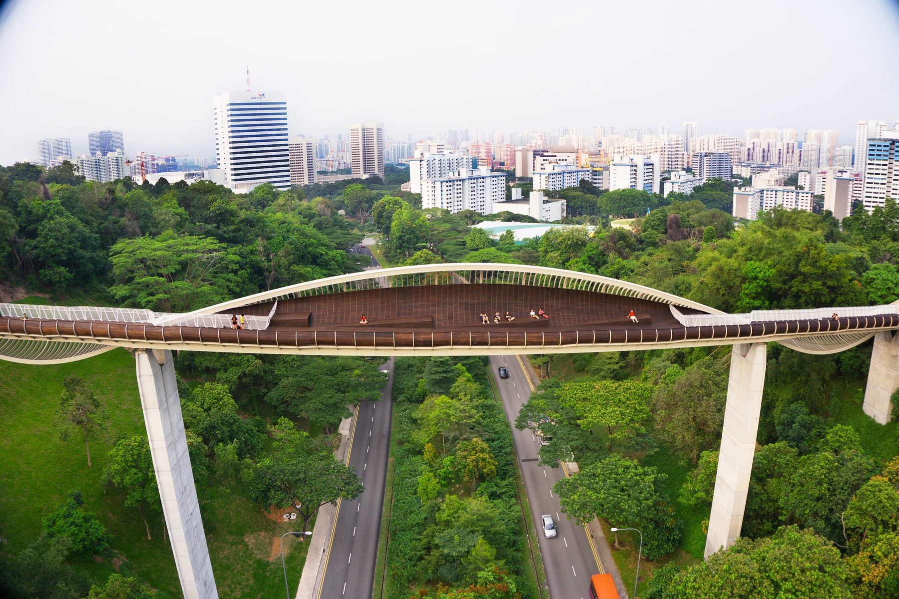
The 10-kilometre Southern Ridges Trail offers fantastic views of the city and harbour. You can start from the Marang Trail and climb a series of steps to reach the peak of Mount Faber Park. This way, the most strenuous part of the hike will be behind you. Then, continue to the architectural wonder that is Henderson Waves and cross the Telok Blangah Hill Park via the elevated walkway that spans 1.3 kilometres. From there, you’ll have two options. You can either continue to HortPark and Kent Ridge Park, or you can turn to Labrador Nature Reserve. We recommend doing the route twice to explore both endpoints!
How to get there?
From HarbourFront MRT Station, take Exit D and start your hike at Marang Trail.
How long does the hike take?
The Southern Ridges Walk takes between 3 to 5 hours from start to end.
3. North Eastern Riverine Loop

Take a hike along the water’s edge and through the neighbourhoods with the North Eastern Riverine Loop. Covering a total of 26 kilometres, this loop connects 4 parks and 4 neighbourhoods: Buangkok, Punggol, Hougang and Sengkang. Among many highlights, you’ll enjoy the Punggol Promenade Nature Walk which overlooks Coney Island and you can explore the Lorong Halus Wetland which serves as an organic water treatment system.
How to get there?
From Punggol MRT Station, walk 10 to 15 minutes from Punggol Central Road to Sentul Crescent Road.
How long does the hike take?
This trail takes 3 to 4 hours.
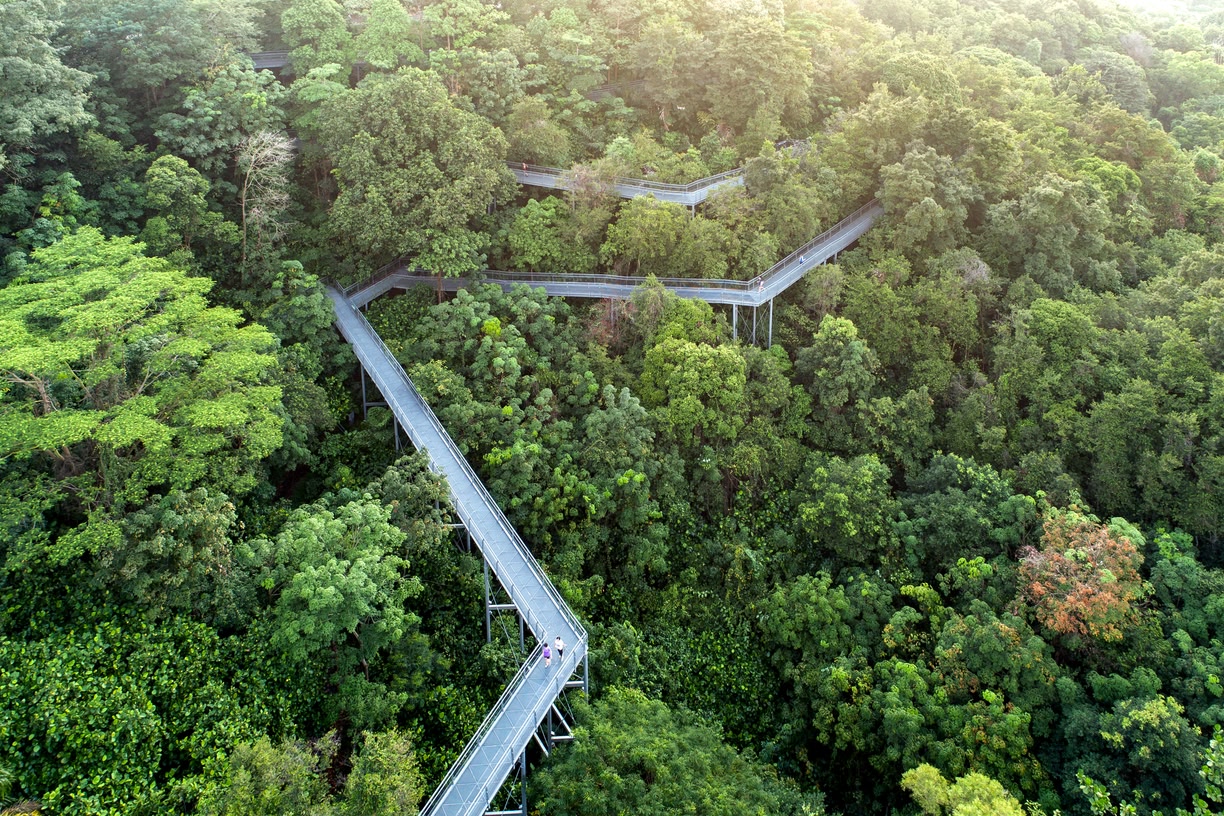
4. MacRitchie TreeTop Walk

MacRitchie Reservoir Park is well-known as one of the best places to hike in Singapore. There are a few different trails to enjoy in this green haven. A local favourite is the one that begins from Venus Drive, taking you up the TreeTop Walk, 250-metre-long bridge that suspends high above the forest canopy. You’ll make a loop by following Petaling Trail and Sime Track back to Venus Drive. Along your walk, keep a lookout for monitor lizards, skinks, squirrels, and especially the mischievous macaques that are adept at pickpocketing.
How to get there?
Take bus number 52, 132, 163, 166, 167, 855 or 980 and alight outside the ESSO station near Venus Drive.
How long does the hike take?
This trail takes an estimated 2 to 3 hours.
5. Nature Trail and Southern Loop at Chestnut Nature Park

A hidden gem, the Chestnut Nature Park is ideal for leisurely walks in Singapore. It comprises two areas: Chestnut Nature Park (South) and Chestnut Nature Park (North). Put together, they form Singapore’s largest nature park. In the northern section, you’ll find a looping Nature Trail that spans 1.5 kilometres. Parts of the rustic trail follow a stream so you’ll hear the soothing sounds of flowing water along your journey. If you’re quiet, you might even see wild boars! Then, enter the Southern Loop for a trek along a more challenging terrain. You’ll march along winding slopes under a forest canopy before returning right where you began at Chestnut Point.
How to get there?
Take bus 700 or 966 and alight at Block 202, Petir Road. From the bus stop, walk about 2 kilometres (30 minutes) to Chestnut Nature Park.
How long does the hike take?
The Nature Trail takes 30 minutes while the Southern Loop takes 40 minutes.
6. Singapore Botanic Gardens Loop

The country’s very own UNESCO World Heritage Site, the Singapore Botanic Gardens dates back to the 1800s. Today, it houses nearly 10,000 species of plants and features the world’s largest orchid display! You can make a 6-kilometre loop of the immaculate gardens to discover its rich heritage while stretching your legs. If you wish to explore certain sections of the gardens in detail, such as the National Orchid Garden, look into the specific maps available.
How to get there?
Take bus number 7, 7B, 75, 77, 105, 106, 123, 174 or 174e to Napier Road. From there, you’re five minutes away from the Tanglin Gate entrance of the Botanic Gardens.
How long does the hike take?
A loop of the Singapore Botanic Garden takes about 2 hours.
7. Sungei Buloh Wetland Reserve Loop

The Sungei Buloh Wetland Reserve is truly an ecological gem. Singapore’s first ASEAN Heritage Park, this wetland boasts an extensive mangrove forest. The site alone is home to nearly half of the world’s true mangrove plant species. Keep your eyes peeled on the surface of the water while you stroll along the boardwalk; you might spot crabs, mudskippers, shellfish, water snakes and mud lobsters. Not all the interest is found on the ground, though. Throughout the year, kingfishers and sunbirds flutter from tree to tree and during the migratory season (from September to March), flocks of plovers and sandpipers stop by the reserve for a rest.
How to get there?
Take Bus 925 from Kranji MRT Station and alight at Kranji Reservoir Carpark B.
How long does the hike take?
The full loop of Sungei Buloh takes about 2.5 hours.
8. Bukit Timah Nature Reserve Trail

This list isn’t complete if we don’t include the highest natural point in the country. Standing at nearly 164 metres, Bukit Timah Hill is as close as you can get to scaling a mountain in Singapore. Notwithstanding the modest height of the hill, you’ll surely get a good workout from taking the trail to the summit. During your trek, you’ll be accompanied by the songs of the forest and the constant buzz of the cicadas. You may also come across a reminder of World War II in the form of a huge bronze plaque that recounts the Battle of Bukit Timah.
How to get there?
Take bus 67, 75, 170, 173, 184, 852 or 961. Alight along Upper Bukit Timah Road, opposite Bukit Timah Shopping Centre.
How long does the hike take?
The trail that leads from the visitor centre directly to the summit of the hill takes 45 minutes to an hour.
Read more: Best cycling routes in Singapore
What gear do you need?
Your most important gear for walks in Singapore would be a trusty pair of shoes. Other than that, don’t forget to bring sufficient water, sunscreen and insect repellent. You also want to be armed with an umbrella or a rain jacket in case the weather takes a turn. Last but not least, you could appreciate some snacks and a change of clothes for the journey home.
When is the best time to hike in Singapore?
Any local will tell you that you can go trekking in Singapore at any time of the year. It’s pretty much constantly hot and humid no matter the month. Some months may see heavier rainfall than others, in particular December to early March and June to September. However, you shouldn’t be deterred from planning a hike in Singapore during these months. Just check the weather forecast to avoid the rain!
On top of that, if you’re not a fan of being roasted by the blazing Singapore sun, set off for your hike in the morning or late afternoon. While you can still hike in the mid-afternoon, be prepared for the heat and hydrate yourself frequently.
Want to read more?
- Singapore staycations in Orchard: top staycation picks to help you choose the perfect spot for a little rest and retreat.
- 10 romantic Singapore staycations for couples: ideas to help make planning your next romantic occasion easier and hassle-free.